-
Hydrogeologic Atlas of Bayfield County, Wisconsin
Analysis of the groundwater resources in Bayfield County, Wisconsin. Includes report, five plates, and digital data.-
Hydrogeologic Atlas of Bayfield County, Wisconsin [appendices]
2019
Data: Documents (.pdf file format)
-
Hydrogeologic Atlas of Bayfield County, Wisconsin [GIS data]
2019
GIS Data: File geodatabase (.gdb file format)
-
Generalized Water-Table Elevation Map of Bayfield County, Wisconsin [plate 1]
2019
Plate: 29.5 in x 39.5 in, scale 1:100,000
-
Depth to Water Table Map of Bayfield County, Wisconsin [plate 2]
2019
Plate: 29.5 in x 39.5 in, scale 1:100,000
-
Depth to Bedrock Map of Bayfield County, Wisconsin [plate 3]
2019
Plate: 29.5 in x 39.5 in, scale 1:100,000
-
Groundwater Recharge Map of Bayfield County, Wisconsin [plate 4]
2019
Plate: 29.5 in x 39.5 in, scale 1:100,000
-
Groundwater Susceptibility Map of Bayfield County, Wisconsin [plate 5]
2019
Plate: 29.5 in x 39.5 in, scale 1:100,000
-
Characterization of Groundwater Resources in the Chequamegon-Nicolet National Forest, Wisconsin
Results of a comprehensive review and analysis of groundwater resources in the Chequamegon-Nicolet National Forest. The study was divided by location into four reports corresponding to the four main land units: Medford, Nicolet, Park Falls, and Washburn/Great Divide. Each report describes the results of the inventory, modeling, and analysis.-
Characterization of Groundwater Resources in the Chequamegon-Nicolet National Forest, Wisconsin: Medford Unit [GIS data]
2018
GIS Data: File geodatabase (.gdb file format)
-
Characterization of Groundwater Resources in the Chequamegon-Nicolet National Forest, Wisconsin: Medford Unit [plates]
2018
Map: 10 maps, 11 in x 17 in
-
Characterization of Groundwater Resources in the Chequamegon-Nicolet National Forest, Wisconsin: Nicolet Unit [GIS data]
2018
GIS Data: File geodatabase (.gdb file format)
-
Characterization of Groundwater Resources in the Chequamegon-Nicolet National Forest, Wisconsin: Nicolet Unit [plates]
2018
Map: 20 maps (10 each, northern and southern Nicolet Unit), 11 in x 17 in
-
Characterization of Groundwater Resources in the Chequamegon-Nicolet National Forest, Wisconsin: Park Falls Unit [GIS data]
2018
GIS Data: File geodatabase (.gdb file format)
-
Characterization of Groundwater Resources in the Chequamegon-Nicolet National Forest, Wisconsin: Park Falls Unit [plates]
2018
Map: 10 maps, 11 in x 17 in
- 2 more...
-
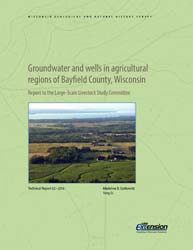
Groundwater and Wells in Agricultural Regions of Bayfield County, Wisconsin: Report to the Large-Scale Livestock Study Committee
Information and recommendations concerning groundwater and water supply wells in two agricultural regions in Bayfield County, Wisconsin. Includes a report, a water-table map, a set of four cross sections, and GIS data. (Replaces WOFR2015-02.)-
Groundwater and Wells in Agricultural Regions of Bayfield County, Wisconsin [GIS data]
2016
GIS Data: Shapefiles (.shp file format)
-
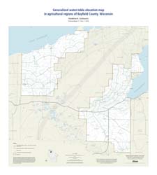
Generalized Water-Table Elevation Map in Agricultural Regions of Bayfield County, Wisconsin [plate 1]
2016
Map: 27 in x 30 in, scale 1:100,000
-
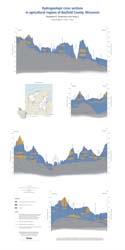
Hydrogeologic Cross Sections in Agricultural Regions of Bayfield County, Wisconsin [plate 2]
2016
Plate: 20 in x 40 in, scale 1:100,000

Publications Catalog
Wisconsin Geological and Natural History Survey