-
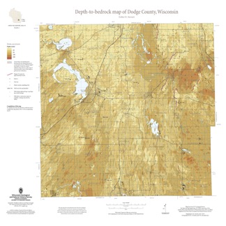
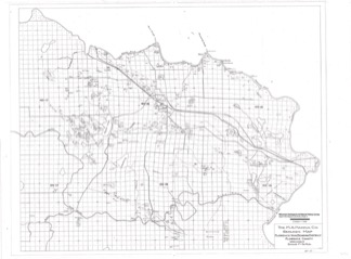
Depth-to-Bedrock Map of Dodge County, Wisconsin
This map shows thicknesses of deposits of unconsolidated materials above the bedrock. Across the county, depth to bedrock ranges from 0 feet, where bedrock is exposed, to over 250 feet within bedrock valleys. Areas with bedrock depths shallower than 20 feet are of particular importance for land-use planning and to the construction stone industry. Such... -
Quaternary Geology of Columbia, Green Lake, and Marquette Counties, Wisconsin
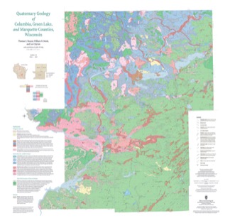
Columbia, Green Lake, and Marquette Counties were glaciated during the last ice age, and large areas were inundated with water from proglacial lakes and large meltwater rivers that occupied the valleys of the existing Wisconsin and Fox Rivers. These processes resulted in rolling upland hills, including drumlins punctuated by low-lying areas dominated by...-
GIS Data for the Quaternary Geology of Columbia, Green Lake, and Marquette Counties, Wisconsin [dataset 1]
2021
GIS Data: GeMS file geodatabase, shapefiles, GeoPackage, and metadata
-
Quaternary Geology of Columbia, Green Lake, and Marquette Counties, Wisconsin [plate 1]
2021
Map: 35 in x 34 in, scale 1:100,000
-
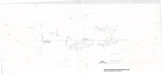
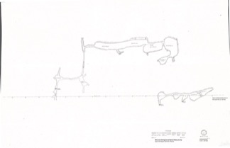
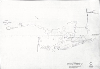
Florence Iron Mine: Historical Maps Showing Location of Surface Development, Regional Setting, and Underground Workings
From 1880 to 1931, an extensive iron mine operated near the city of Florence in northeast Wisconsin. These 21 maps from its middle years of operation are the only surviving records of what exists below the surface. These maps are of historical interest for their record of surface features that are no longer in existence. They may also have potential...-
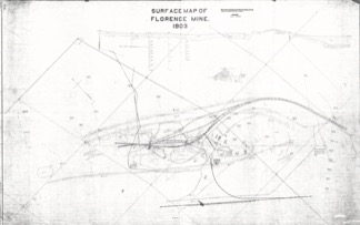
Extent of Florence Mine Surface Development in 1903 [plate 1]
2021
Map: 56 in x 35.1 in, scale 1 in = 100 ft
-
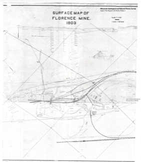
Florence Mine Surface Development in 1903 With Annotated Shaft Locations [plate 2]
2021
Map: 33.3 in x 38.2 in, scale 1 in = 100 ft
-
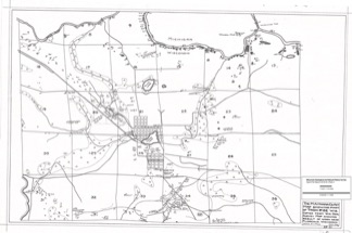
Mines in the Area Adjacent to the City of Florence in 1928 [plate 3]
2021
Map: 29.7 in x 19.7 in, scale 1 in = 1/4 mile
-
Florence Iron Mining District Covering Part of Florence County [plate 4]
2021
Map: 36.3 in x 26.8 in, scale 1 in = 1/2 mile
-
Florence Mine Level 1 With Annotated Shaft Locations and Surface Features [plate 5]
2021
Map: 52.8 in x 24.3 in, scale 1 in = 100 ft
-
Florence Mine Level 1 (1910), Northwest Ore Zone [plate 7]
2021
Map: 27 in x 19 in, scale 1 in = 60 ft
-
Florence Mine Level 2 (1907), Northwest Ore Zone [plate 9]
2021
Map: 27.1 in x 18.8 in, scale 1 in = 60 ft
- 12 more...
-
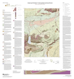
Geologic Map of the Baraboo 7.5-Minute Quadrangle, Sauk County, Wisconsin
The Baraboo quadrangle, records where glaciers stopped in the east-central Baraboo Hills. On this map, 1:24,000 scale, Precambrian igneous and metasedimentary rocks are overlain by Paleozoic sedimentary rocks and, more recently, by glacial deposits. Superb exposures of all three can be found in Devils Lake State Park and Parfreys Glen State Natural Area.-
Geologic Map of the Baraboo 7.5-Minute Quadrangle, Sauk County, Wisconsin
2021
Map: 35 in x 37 in, scale 1:24,000
-
-
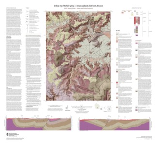
Geologic Map of the Rock Springs 7.5-Minute Quadrangle, Sauk County, Wisconsin
The Rock Springs quadrangle is located in the western Baraboo Hills of south-central Wisconsin. This map, 1:24,000 scale, conveys the rich Precambrian through Quaternary history present on the ground. Here, ancient rocks metamorphosed and folded and were later displaced by a series of faults. Although never glaciated, an ice sheet 8 kilometers to the east...-
Geologic Map of the Rock Springs 7.5-Minute Quadrangle, Sauk County, Wisconsin
2021
Map: 40 in x 36.5 in, scale 1:24,000
-
-
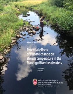
Potential Effects of Climate Change on Stream Temperature in the Marengo River Headwaters
Cold-water trout habitat in Wisconsin is projected to substantially decrease as a result of climate change. The extent of habitat loss depends, in part, on groundwater discharge to streams, which can provide cool-water refuges for trout. Survey hydrogeologists used field measurements and models of groundwater flow and stream temperature to evaluate how...-
GFLOW Groundwater Flow Model of the Marengo River Headwaters [dataset 1]
2021
Data: Groundwater flow model
-
Geodatabase - Three Baseflow Scenarios for the Marengo River Headwaters [dataset 2]
2021
GIS Data: File geodatabase
-
Measurements of Water Chemistry, Streamflow, and Stream Temperature from the Marengo River Headwaters [dataset 3]
2021
Data: Data (spreadsheets)
-
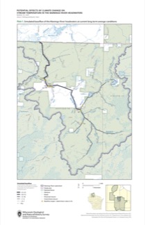
Simulated Baseflow of the Marengo River Headwaters with 21% Increase in Recharge [plate 2]
2021
Map: 11 in x 17 in
-
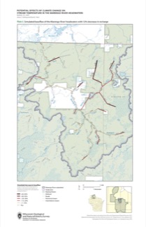
Simulated Baseflow of the Marengo River Headwaters with 12% Decrease in Recharge [plate 3]
2021
Map: 11 in x 17 in
-
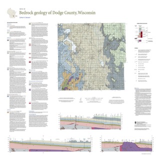
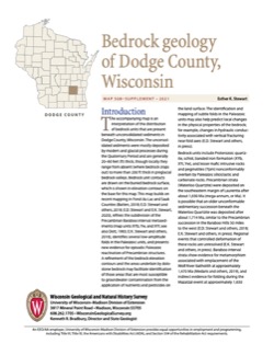
Bedrock Geology of Dodge County, Wisconsin
Dodge County lies in southeast Wisconsin, an area almost entirely covered by glacial deposits. This map interprets the distribution of the buried bedrock units across the county. Geologist Esther Stewart’s refinement of the bedrock elevation contours may help land-use planners identify areas most susceptible to groundwater contamination from applications...-
Supporting Data for the Bedrock Geology of Dodge County, Wisconsin
2021
Data: Tabular data files (Excel)
-
GIS Data for the Bedrock Geology of Dodge County, Wisconsin [dataset 2]
2021
GIS Data: GeMS file geodatabase, shapefiles, GeoPackage, and metadata
-
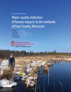
Water-Quality Indicators of Human Impacts to the Wetlands of Door County, Wisconsin
Door County, the narrow peninsula in eastern Wisconsin, is home to numerous wetlands, many of which are fed by groundwater. Poor-quality groundwater discharging to a wetland can alter the ecology of the wetland and harm native plant and animal communities. This report documents a one-year study of six wetlands. Researchers recorded water quality and... -
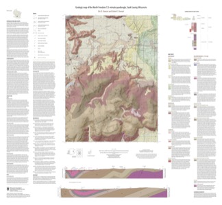
Geologic Map of the North Freedom 7.5-Minute Quadrangle, Sauk County, Wisconsin
The North Freedom quadrangle is located on the South Range of the Baraboo Hills in south-central Wisconsin. The Baraboo Hills are recognized for their ecologic and geologic significance, with superb exposure of Precambrian and Paleozoic rocks and Quaternary sediments. Mapping focused on the Precambrian section, building on past work by subdividing and...-
Geologic Map of the North Freedom 7.5-Minute Quadrangle, Sauk County, Wisconsin
2020
Map: 40 in x 37 in, scale 1:24,000
-
GIS Data for the Geologic Map of the North Freedom 7.5-Minute Quadrangle, Sauk County, Wisconsin (version 2) [dataset 1]
2020
GIS Data: GeMS file geodatabase, shapefiles, and metadata. Supersedes previous file geodatabase format (DI version 1)
-
-
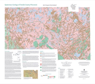
Quaternary Geology of Oneida County, Wisconsin
Oneida County, in northern Wisconsin, is a mostly forested area dotted with lakes and wetlands. The watery landscape is a legacy of a time when glaciers flowed across the area. Geologists Attig and Rawling mapped the Quaternary geology of the county, documenting where the glaciers paused, the sediments that were deposited, and the landforms that were...-
Quaternary Geology of Oneida County, Wisconsin (version 2) [GIS data]
2020
GIS Data: GeMS Level 3 file geodatabase and metadata. Supersedes previous GeMS Level 1 format (DI version 1).
-
Assessing Groundwater Quality in Kewaunee County, Wisconsin, and Characterizing the Timing and Variability of Enteric Pathogen Contamination within the Dolomite Aquifer in Northeastern Wisconsin
Documentation of two studies looking at the Silurian dolomite aquifer in northeastern Wisconsin. Researchers quantified the extent of contamination from coliform bacteria, E. coli, and nitrate in Kewaunee County’s private wells. They also examined how wastewater from septic systems and livestock manure interact with environmental conditions and geology... -
Assessing Seasonal Variations in Recharge and Water Quality in the Silurian Aquifer in Areas with Thicker Soil Cover
Documentation of variations in groundwater levels and selected water-quality parameters in four wells completed in the Silurian dolomite aquifer in northeast Wisconsin (Brown, Calumet, Kewaunee, and Manitowoc Counties).-
Assessing Seasonal Variations in Recharge and Water Quality in the Silurian Aquifer in Areas with Thicker Soil Cover
2019
Report: 38 p. + appendix (4 oversized pages)
-
-
Methods and Best Practices for Surveying Springs in Wisconsin
Description of the field methods and data management procedures used to produce the Springs Inventory (see Bulletin 113). -
An Inventory of Springs in Wisconsin
Report, database, field protocol, photos, and site sketches documenting the multi-year project inventorying springs in Wisconsin with discharge rates of at least 0.25 cubic feet per second. -
Hydrogeologic Atlas of Bayfield County, Wisconsin
Analysis of the groundwater resources in Bayfield County, Wisconsin. Includes report, five plates, and digital data.-
Generalized Water-Table Elevation Map of Bayfield County, Wisconsin [plate 1]
2019
Plate: 29.5 in x 39.5 in, scale 1:100,000
-
Depth to Water Table Map of Bayfield County, Wisconsin [plate 2]
2019
Plate: 29.5 in x 39.5 in, scale 1:100,000
-
Depth to Bedrock Map of Bayfield County, Wisconsin [plate 3]
2019
Plate: 29.5 in x 39.5 in, scale 1:100,000
-
Groundwater Recharge Map of Bayfield County, Wisconsin [plate 4]
2019
Plate: 29.5 in x 39.5 in, scale 1:100,000
-
Groundwater Susceptibility Map of Bayfield County, Wisconsin [plate 5]
2019
Plate: 29.5 in x 39.5 in, scale 1:100,000
-
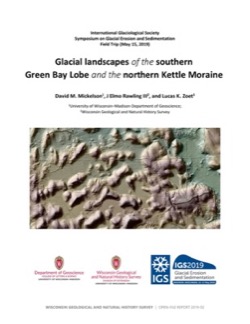
Glacial Landscapes of the Southern Green Bay Lobe and the Northern Kettle Moraine
Field trip guidebook from the International Glaciological Society Symposium on Glacial Erosion and Sedimentation, May 15, 2019. -
Geochemistry and Mineralogy of the Wonewoc-Tunnel City Contact Interval Strata in Western Wisconsin
Results of regional study characterizing the elemental composition of rocks found at the Wonewoc-Tunnel City contact interval in west-central and southwest Wisconsin.-
Geochemistry and Mineralogy of the Wonewoc-Tunnel City Contact Interval Strata in Western Wisconsin [appendices]
2019
Data: PDF files + Excel spreadsheet
-
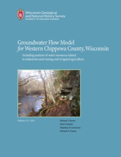
Groundwater Flow Model for Western Chippewa County
This report documents the groundwater flow model that was developed for western Chippewa County, Wisconsin. It also presents analyses that were run to evaluate how industrial sand (frac sand) mining and irrigated agriculture--might affect the water table and base flows of nearby headwater streams. -
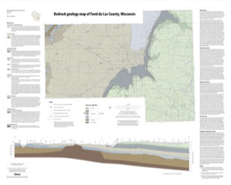
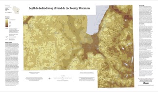
Bedrock Geology of Fond du Lac County, Wisconsin
Two plates showing the bedrock geology and depth to bedrock in Fond du Lac County, Wisconsin. Includes GIS data (shapefiles and grid files).-
GIS Data for the Bedrock Geology of Fond du Lac County, Wisconsin (version 2) [dataset 1]
2018
GIS Data: GeMS file geodatabase, shapefiles, and metadata. Supersedes previous shapefile format (DI version 1)
-
Bedrock Geology Map of Fond du Lac County, Wisconsin [plate 1]
2018
Plate: Scale 1:100,000, 35.75 in x 28.75 in
-
Depth to Bedrock Map of Fond du Lac County, Wisconsin [plate 2]
2018
Plate: Scale 1:100,000, 33 in x 19.25 in
-
-
Characterization of Groundwater Resources in the Chequamegon-Nicolet National Forest, Wisconsin
Results of a comprehensive review and analysis of groundwater resources in the Chequamegon-Nicolet National Forest. The study was divided by location into four reports corresponding to the four main land units: Medford, Nicolet, Park Falls, and Washburn/Great Divide. Each report describes the results of the inventory, modeling, and analysis.-
Characterization of Groundwater Resources in the Chequamegon-Nicolet National Forest, Wisconsin: Medford Unit [GIS data]
2018
GIS Data: Geodatabase, metadata
-
Characterization of Groundwater Resources in the Chequamegon-Nicolet National Forest, Wisconsin: Medford Unit [plates]
2018
Map: 10 maps, 11 in x 17 in
-
Characterization of Groundwater Resources in the Chequamegon-Nicolet National Forest, Wisconsin: Nicolet Unit [GIS data]
2018
GIS Data: Geodatabase, metadata
-
Characterization of Groundwater Resources in the Chequamegon-Nicolet National Forest, Wisconsin: Nicolet Unit [plates]
2018
Map: 20 maps (10 each, northern and southern Nicolet Unit), 11 in x 17 in
-
Characterization of Groundwater Resources in the Chequamegon-Nicolet National Forest, Wisconsin: Park Falls Unit [GIS data]
2018
GIS Data: Geodatabase, metadata
-
Characterization of Groundwater Resources in the Chequamegon-Nicolet National Forest, Wisconsin: Park Falls Unit [plates]
2018
Map: 10 maps, 11 in x 17 in
- 2 more...

Publications Catalog
Wisconsin Geological and Natural History Survey